Last weekend a depleted group comprising Gary, Martin, John and myself went for an overdue walk in the Southern ACT - the far south of Namadgi National Park. In selecting a walk for this adventure I wanted to choose something mildly challenging but interesting. The walk we chose is an anti-clockwise loop walk from a turn-off near the Mt Clear camp ground turn off on the Boboyan Road heading West towards the Old Boboyan Road and then South toward the ACT border before looping back East and North to complete the loop. The interest is that the loop passes close by the ruins of three old homesteads dating from before the area became National Park. Son Dominic and I had done this walk twice, the first time overshooting the turn back to the east and ending up down on the Yaouk Road - considerably further than we had intended to walk. I had also done it in the clock-wise direction with friend Pia and an ANU walking group so I thought I knew the walk pretty well.
On the Saturday morning of the walk, which I remembered as being between 4 and 5 hours duration, Canberra and the southern ACT was experiencing its first decent rain in quite a while. So much so that, as I waited for Martin, Gary, and John at our agreed meeting place of Namadgi Visitor Centre I was wondering if we would be walking at all. However, once we all met up we agreed to head down to where the walk starts and then make a decision.
When we arrived at the turn-off to the beginning of the walk it was still raining heavily. The gravel road which we travelled on past the Gudgenby Homestead was quite muddy and slippery in places making the journey a little slower than usual. The consensus on reaching the locked gate at the start of the walk was to kit up in our rain-proof gear and start off. We could always turn back if things became too extreme, so we duly headed off. The track was quite muddy and slippery but walking wasn't too bad. I was walking in shorts as was John, although he was wearing gaiters. Gary was wearing waterproof long overpants, and Martin was wearing long pants which were anything but waterproof. In the first kilometre of walking Martin's lower trouser legs became very wet and cold.
The first 5 or 6 kilometres of the walk are across open 'farmland' with flattish plains to the north and wooded hills to the south. After about 2-3 kilometres the ruin of Boboyan Homestead is reached. There is little more than a chimney there now.
 John, Gary, and Martin with the chimney of the old
Boboyan Homestead in the background.
Continuing westward, the track forks near where it meets up with the section of the Old Boboyan Road which heads north toward Gudgenby Homestead. Our way was now to head south along the Grassy Creek track toward the ACT border. At the track intersection we took the opportunity for a short break. The rain had eased up to just the odd droplets by this time and we were all feeling much better about the day.

Gary and Martin with some of the 'locals' in the background.
We had passed several grazing mobs of Eastern Grey Kangaroos on the walk thus far with largest mob comprising between 30 and 40 animals.
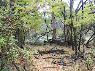
From this point we headed south where the track now proceeds to rise up a series of low hills. After the first rise the ruins of the Lone Pine Homestead are reached. Little remains of the former homestead except the fireplace which has a large eucalypt growing through it. The 'pine' after which the homestead was named has been long gone.
 Remains of Lone Pine Homestead. The fireplace is surrounded
by exotic deciduous trees which have deposited a thick layer of
autumnal leaves.
We had passed several grazing mobs of Eastern Grey Kangaroos on the walk thus far with largest mob comprising between 30 and 40 animals.
From this point we headed south where the track now proceeds to rise up a series of low hills. After the first rise the ruins of the Lone Pine Homestead are reached. Little remains of the former homestead except the fireplace which has a large eucalypt growing through it. The 'pine' after which the homestead was named has been long gone.
 Remains of Lone Pine Homestead. The fireplace is surrounded
by exotic deciduous trees which have deposited a thick layer of
autumnal leaves.
By the time we reached the homestead we had been walking for a little over two hours, it now being just on noon, so we decided to make it our lunch break. By now it was quite sunny although the threat of rain was still there in the South-west.
Near the homestead we say a rock to which someone has affixed a metal plaque. It is in memoriam to the homesteaders infant sun who died there in 1915. Being so remote, medical help would have been hard to come by and would have required most of a day's travel whether going north or south.
As we headed on toward the south John and I, walking ahead of Gary and Martin, startled a Gang Gang Cockatoo which departed noisily overhead. From the Lone Pine Homestead to the point where the track loops eastwards near the park/ACT border the walk is pleasant but uneventful. It proceeds up a series of low rises interspersed with small open, tussocky plain areas. As we reached the eucalypt forest again just before the park border it started to rain again so it was back into raingear before continuing.
We had no trouble spotting the turn-off left to take us back to the east as it has been the subject of National Park attention to make a more robust and open firetrail along this boundary of the park. Dominic had mentioned this and my impression was that they had just opened up the original track for fire access. However, it turned out to be not so as the new track runs along the border although dipping and weaving to avoid rocky outcrops. They had also put a log across the original track to discourage anyone from going that way - possibly to preserve the more fragile ground of the plains. With this new track being our means of completing the walk, I estimate that it added about 5km to the original 20km estimate. But anyway, apart from the occasional rain squalls it had turned into a great day for walking and we were all feeling pretty good. Perhaps becoming a little footsore but without any major problems developing.
Along the newly bulldozed track there were some significantly steep ups and downs but fortunately each lasting no more than 100 metres with ascents/descents of up to about 20 metres. All of this, of course, leads to a relatively slow pace. After about two and a half to three hours of walking from Lone Pine Homestead we eventually reach th epoint where the track turns once again northward. The GPS which I was carrying in case of emergence confirmed that we were near to the south-east corner of the park so we knew that our destination was not too far away. At this stage the bulldozed track leaves the eucalypt forest to emerge onto the open plains. A little more walking had us overlooking Westerman's hut. This, and Brayshaw's Hut are in significantly better condition than the two ruins we had encountered so far.
 Westerman's Hut, Namadgi National Park
Near the homestead we say a rock to which someone has affixed a metal plaque. It is in memoriam to the homesteaders infant sun who died there in 1915. Being so remote, medical help would have been hard to come by and would have required most of a day's travel whether going north or south.
As we headed on toward the south John and I, walking ahead of Gary and Martin, startled a Gang Gang Cockatoo which departed noisily overhead. From the Lone Pine Homestead to the point where the track loops eastwards near the park/ACT border the walk is pleasant but uneventful. It proceeds up a series of low rises interspersed with small open, tussocky plain areas. As we reached the eucalypt forest again just before the park border it started to rain again so it was back into raingear before continuing.
We had no trouble spotting the turn-off left to take us back to the east as it has been the subject of National Park attention to make a more robust and open firetrail along this boundary of the park. Dominic had mentioned this and my impression was that they had just opened up the original track for fire access. However, it turned out to be not so as the new track runs along the border although dipping and weaving to avoid rocky outcrops. They had also put a log across the original track to discourage anyone from going that way - possibly to preserve the more fragile ground of the plains. With this new track being our means of completing the walk, I estimate that it added about 5km to the original 20km estimate. But anyway, apart from the occasional rain squalls it had turned into a great day for walking and we were all feeling pretty good. Perhaps becoming a little footsore but without any major problems developing.
Along the newly bulldozed track there were some significantly steep ups and downs but fortunately each lasting no more than 100 metres with ascents/descents of up to about 20 metres. All of this, of course, leads to a relatively slow pace. After about two and a half to three hours of walking from Lone Pine Homestead we eventually reach th epoint where the track turns once again northward. The GPS which I was carrying in case of emergence confirmed that we were near to the south-east corner of the park so we knew that our destination was not too far away. At this stage the bulldozed track leaves the eucalypt forest to emerge onto the open plains. A little more walking had us overlooking Westerman's hut. This, and Brayshaw's Hut are in significantly better condition than the two ruins we had encountered so far.
 Westerman's Hut, Namadgi National Park
By this time it was just after 3PM - approximately the time I had estimated we would be back at the car! Looking at the map we could see that there would be still another one and a half to two hours walking ahead of us. The late afternoon sunshine, however, made for superb walking so even though we were all a bit footsore by now it was not an overly daunting prospect.
Just north of Westerman's hut, the track takes another dive toward the east where it exits from the park onto the Boboyan Road. Just before we got to this point we watched a pair of Wedgetail Eagles majestically take off toward the south. When you get up to close to these birds you get to appreciate how big they are. With a length up to about 1 metre, when standing on the ground they are almost a metre tall. The outstretched wings of a fully grown specimen reach up to 2.3 metres. Dominic and I once drove towards a pair which were feeding on carrion by the roadside. One of them took off as we approached and flew closely over the top of the car, its wings spanning wider than the car's width. The other, still on the ground, was just below eye height as we went past.
Reaching Boboyan Road, which runs from Gudgenby Homestead to Adaminaby in New SOuth Wales, we now faced the trudge along the undulating gravel surface to Brawshaw's Hut on the last leg back to the car. Along the way, Bush Wallabys kept pace with us just outside the forest fringe.
 Brayshaw's Hut in the late afternoon sun.
After a short stop at Brayshaw's Hut to take a picture, we embarked the real last leg of the journey whcih was, fortunately, 'downhill on average', arriving back at John's car just before 5PM in the fast-fading light.
While our 5-hour walk had turned into 7 hours and had started off in rain, it had turned into a brilliant day and I was pleased that, although footsore, everyone said that it had been a great walk.
Just north of Westerman's hut, the track takes another dive toward the east where it exits from the park onto the Boboyan Road. Just before we got to this point we watched a pair of Wedgetail Eagles majestically take off toward the south. When you get up to close to these birds you get to appreciate how big they are. With a length up to about 1 metre, when standing on the ground they are almost a metre tall. The outstretched wings of a fully grown specimen reach up to 2.3 metres. Dominic and I once drove towards a pair which were feeding on carrion by the roadside. One of them took off as we approached and flew closely over the top of the car, its wings spanning wider than the car's width. The other, still on the ground, was just below eye height as we went past.
Reaching Boboyan Road, which runs from Gudgenby Homestead to Adaminaby in New SOuth Wales, we now faced the trudge along the undulating gravel surface to Brawshaw's Hut on the last leg back to the car. Along the way, Bush Wallabys kept pace with us just outside the forest fringe.
 Brayshaw's Hut in the late afternoon sun.
After a short stop at Brayshaw's Hut to take a picture, we embarked the real last leg of the journey whcih was, fortunately, 'downhill on average', arriving back at John's car just before 5PM in the fast-fading light.
While our 5-hour walk had turned into 7 hours and had started off in rain, it had turned into a brilliant day and I was pleased that, although footsore, everyone said that it had been a great walk.


